Service request Form
![]()
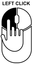
Left mouse click on the map and lock or unlock scroll wheel zoom.
|
![]()
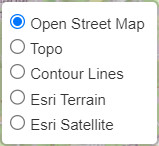
5 Types of maps: Open Street Map, Topographic, Countour Lines, ESRI Terrain and ESRI Satellite.
|
![]()
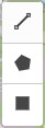
3 Types of design: Lines, Polygons and Squares.
|
Help filling out the form
Name and Email: These fields are automatically filled by your session but you could update them for this project.
Project reference: Suggestive reference for the project, an unique identification that could represent it.
Expected start and end dates: Identification of the expectance day for the start and the end for the survey.
Type of Survey: Selection of a/all type of surveys required for the project.
Specification list/details for the project: Enumerate all requirements for the project(Ex.: type of lidar, GSD, Front and Side Overlap, etc).
Upload project files: Upload files that could be important or help for the overview of the requirements of the project. Here you could also upload the kml files of the areas of the project.